Ice builds as Michigan endures historic blizzard
Published in News & Features


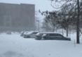


TRAVERSE CITY, Mich. — A historic storm that dumped more than 4 feet of snow on parts of Michigan's Upper Peninsula tapered off Tuesday, but ice accumulated in northeastern lower Michigan and other locations as more than 90,000 people still lacked power, and some roads remained impassable.
A station near Round Lake in the U.P.’s Luce County reported 52 inches of snow over 48 hours, followed by 48.5 inches at Cusino Lake in Schoolcraft County at 9 a.m. Tuesday, according to the National Weather Service.
The Round Lake report of 52 inches and the 48.5 inches at Cusino Lake would beat the two-day snow record of 46 inches recorded on Dec. 10, 1995, at a Sault Ste. Marie station in the UP's Chippewa County, according to the National Weather Service.
Those snowfall totals were followed by an observer station two miles south of Herman, in L'Anse Township in Michigan's Baraga County, which reported 45 inches of snow in the past 48 hours at 8 a.m. Tuesday. Another 11 areas reported snow accumulations over two days, between 42.5 inches in one Alper County location and 33.5 inches in Escanaba.
Ben Warren, a meteorologist at the National Weather Service office in in Negaunee Township, Marquette County, said he would have to comb through decades of records to determine just how many communities across the U.P. broke records, but "it would not surprise me at all if records were broken in the south central and northern part of the peninsula with just the incredible amount of snow we received."
Warren said by the time it stopped snowing at his office Tuesday morning, the snow measured 37.6 inches, just edging out a March 1997 blizzard as the station's snowiest two-day total ever.
Precisely measuring the accumulation is challenging due to the 50- to 60-mph wind gusts that accompanied the snow, the NWS Marquette office said in a social media post.
According to a preliminary analysis, high-elevation parts of Baraga, Marquette and Alger counties got the worst of the storm, with "nearly continuous moderate to heavy snow."
Warren said the blizzard ranks with the infamous blizzard of 1978 among the U.P.'s worst on record.
"This one had widespread impacts," he said. "Every authority out there was saying, 'Do not travel. Do not go anywhere.'
"There were no reports of anything serious like roof collapses or fatalities, but … essentially, nearly every business was closed for two days," he added.
Munising resident lives above 5-foot snow drift, calls storm the worst one ever
For many communities in the uppermost portion of the lower peninsula, such as Roscommon County and Alpena, ice was more of an issue than snow. Hundreds of schools were shut down for another day on Tuesday, and several offices were delayed in opening.
Sue Dempsey, who lives in Munising on Lake Superior, lives in her second-floor apartment above a 5-foot-tall snow drift. She said the blizzard was the worst she's seen in Munising, and she's lived there since the 1950s.
“There was a snowstorm that was big in 1978, and that one was really bad, and this one topped it," Dempsey said.
Dempsey said she and her neighbors bought groceries before the storm rolled in on Sunday evening and were "hunkering down" on Tuesday. She's been able to connect with people over text and phone.
Dempsey has also been able to connect with neighbors in her building. She said she shoveled snow with her downstairs neighbor.
"He was blowing snow, and I was shoveling the steps around the garage. We just laughed about it. What else can you do?” she said.
Because the Munising area has had a snowy winter season, Dempsey is concerned about snowplowing efforts. She said the area is "running out of room to put the snow."
"People just have to be patient, you know? It is what it is," she said.
When will weather conditions improve?
Despite the snow totals, the weather in the Upper Peninsula was calming down on Tuesday. Meteorologist Warren said the winds that were between 50-70 miles per hour during the storm had died down to the 20s and were going to be in the teens by the end of Tuesday.
"We just have some lingering, light lake effect snow," Warren said Tuesday morning.
Warren said light snow is possible in the Upper Peninsula later in the week, but "nothing substantial."
At the National Weather Service's Gaylord office, Meteorologist Joe Delizio said the weather event was beginning to taper off there as well, with the exception of some light lake effect snow showers. He said drivers would be able to travel Tuesday, but that they should be careful.
"Just be cognizant of the light breezes and the snow drifts, things like that," Delizio said.
Ice accumulation
Like last year’s storm in late March, this year’s storm resulted in significant ice accumulation in northeast lower Michigan. Four towns in the region, including Presque Isle and the Town of Hubbar, reported 0.38 inches of ice in the past 48 hours, according to the National Weather Service.
Three different areas of Alpena had 0.28 to 0.31 inches of ice, while a couple of areas in Grayling had between a quarter-inch and 0.28 inches of ice in the past two days.
Connie Irish, 43, was shoveling snow in her driveway off West 16 Road in Mesick on Tuesday afternoon. The trees in her driveway were cracking from ice as she and her sons shoveled.
Irish said her power has been off and on since Saturday. She said several neighbors are relying on generators.
"What makes this storm especially bad is the ice," she said.
The ice was so bad last year that the National Guard was deployed to help. The damage affected about 1 million acres of state-owned forest land, with state Department of Natural Resources estimating it would cost about $40 million for cleanup and restoration.
During the 2025 ice storm, the greatest amounts of ice accumulation happened across eastern Antrim, Otsego, Montmorency, Presque Isle, Cheboygan, Emmet, and Mackinac counties, where a quarter to half an inch of icing was observed, according to the National Weather Service.
The heaviest icing was witnessed in portions of Emmet and Cheboygan counties, with reports of 0.75 inches of icing, while widespread icing of up to 1 inch was observed across far eastern Antrim, Otsego, and Montmorency counties, the NWS found.
Schools still closed
Even with improved conditions Tuesday, schools throughout Michigan remained closed. Marquette Area Public Schools, Cheboygan Area Schools, Gaylord Community Schools and Traverse City Area Public Schools were all closed Tuesday. Cheboygan Area Schools said many side and back roads throughout the district "remain impassable."
Cheboygan City Hall was closed Tuesday, while Alpena City Hall was not open to the public until noon Tuesday. Roscommon County municipal offices were closed until Tuesday. Gaylord City Hall was open to the public Tuesday.
Grand Traverse County's public agencies issued a joint statement Monday night, urging residents to stay off the roads, pointing out that conditions across the county were "becoming life-threatening."
The statement noted nearly 3 feet of snow had fallen in some areas, and that the county was experiencing wind gusts of 40-50 miles per hour and wind chill values below zero.
"Many roads are becoming more impassable due to deep snow drifts," the statement reads. "If you choose to travel tonight and become stranded, emergency responders may be severely delayed reaching you. For your safety and the safety of first responders, please stay home and continue to ride out the remainder of this storm."
Ian Ashton, 42, lives in Traverse City with his wife and children. He said the storm was a "little like being back in the pandemic" with the roads being closed.
Ashton posted a video to his Facebook of an intersection a little over a mile from his house. In it, streetlights blow in the wind, and there's little visibility due to the sleet falling.
"I didn't realize there'd been a 'state of emergency' called," Ashton said. "I took my son to get gas and firewood. There was near-zero visibility. It took us 40 minutes to make the normally 5-minute drive to the gas station a mile away."
His kids, Ashton said, were loving the time off school.
"They haven't been at school since Thursday," he said. "We live on a hill; the neighbor's kids have been skiing down it. It's like a weekend."
Power outages
Nearly 92,000 power company customers across Michigan remained in the dark Tuesday afternoon.
Consumers Energy, which provides service to 1.8 million customers in 62 of Michigan's Lower Peninsula counties, reported that 70,774 of its customers were without power, but 96.4% of its total customers had service as of 2:45 p.m.
Company officials said its crews worked through the night and were able to restore power to a significant number of customers — more than 100,000 — while repairing damage to equipment. They also said more than 700 crews were continuing restoration work on Tuesday and Wednesday.
DTE Energy said 1,007 of its customers had outages, but 99.96% of its total customers had electricity.
Alpena Power Co. said about 12,063 of its 16,781 customers were without electricity as of 2:45 p.m. Tuesday.
Great Lakes Energy, which serves western northern Michigan from the tip of the mitten to Holland, reported that about 3,812 of its more than 133,000 customers were without power on Tuesday afternoon.
Presque Isle Electric & Gas Co-op, which serves a nine-county region in northeast Michigan, said about 946 of its more than 35,000 customers had their service interrupted.
_____
Staff Writer Charles E. Ramirez contributed.
_____
©2026 www.detroitnews.com. Visit at detroitnews.com. Distributed by Tribune Content Agency, LLC.


Comments